We concentrate on production of image
interpretation chains for the users. Our expertise is
recognised in domestic and international market with
specialisation in forestry applications, geometric and radiometric
corrections of images and image mosaicing.The image data is
originated in airborne or satellite instruments. We analyse both
optical and radar images.

We use a new concept in data management to reach the appropriate set of parameters for our customers' desired
operations. Capturing data, creating information and seeking the
neccesary knowledge needed to reach our customers' demands, is
drilling down through masses of data for the right response.
Professionally, we use highly qualified experts with a long list of
successful operations and project implementations. We see that our
customer receives the personal attention of each and every
professional in the new data drilling process.
Photogrammetry is about measurement of objects
by means of photographs. The main application is production of
technical and topographic maps or data bases from aerial photographs
( photogrammetric mapping ). There are many other uses, among others
production of height or surface models of the landscape and of
industrial objects as well as their changes. The technology is
changing much. Instead of Photographs, digital images, which can be
processed in a computer, may be used. Photographs are digitized by
means of scanners or digital images are produced by means of digital
cameras. The processing of digital images makes possible new
applications and automation of the process. It is expected that
large format images can be taken with digital flight cameras in a
few years.
Whether you're looking to address current
business challenges, future technology needs, or a combination of
both, IN-RIMT has the solution for your company. Across the country,
IN-RIMT has supported the computing needs of its customers for more
than 11 years. Today we serve the needs of the professional
community with a range of software and hardware services that
support many technical disciplines. We provide total support for all
your computing needs.
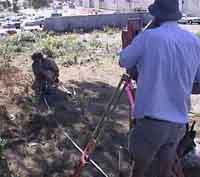
IN-RIMT established in 1992 provides
survey and dimensional engineering services to the construction,
civil, petrochemical and railway industries. We started out purely
as Land Surveyors. We have now expanded to offer a very wide scope
of measurement services. Our services in this sector range from
small site boundary surveys to the monitoring of underground tunnel
deformation, from setting out grid lines for building construction
to complete measured building surveys. The projects vary in nature,
but our principle of producing high quality work is always
paramount.