

| What are
we........? We generate information on natural resources and provide management solutions using advanced technologies such as Remote Sensing,Geographic Information System (GIS) etc. 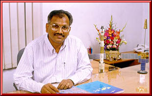 Total Solution Provider We Have Specialists in  Remote Sensing
Geographic Information System (GIS)
Computer Aided Designing (CAD) Geology Soils Geography Forestry Water
Resources Engineering Irrigation
Sector Structural Engineering Remote Sensing
Geographic Information System (GIS)
Computer Aided Designing (CAD) Geology Soils Geography Forestry Water
Resources Engineering Irrigation
Sector Structural Engineering
Dr. Subba Rao Pavuluri
Managing Director Geo -
Technical Investigation Public Health
Engineering Roads & Highway Planning &
Designing
 Urban Planning
Ports & Harbours Planning & Designing
Sociology Socio-Economics
Agricultural Economics Social
Economics Environmental Engineering Software Development Urban Planning
Ports & Harbours Planning & Designing
Sociology Socio-Economics
Agricultural Economics Social
Economics Environmental Engineering Software DevelopmentSurveying  Topography Photogrammetry
Cartography GPS
Topography Photogrammetry
Cartography GPS
FOUNDATION : The techno-economic
development in recent years rendered a new dimension to
developmental planning in modern India. The country has been passing
through a phase when increase in resources-use leads to conflicting
influence on various aspects of environment and resource
development. 
The INDIAN RESOURCES
INFORMATION AND MANAGEMENT TECHNOLOGIES LTD. (IN-RIMT)
has been established to
offer high quality services relating to all aspects of environment, b) The Indian Bureau of Mines, for the preparation of Mining Plans. TECHNICAL COLLABORATION IN-RIMT has Technical Collaboration with : GEOSPACE Satellitenbilddaten GmbH of Germany JODIAN System & Software, Inc. of U.S.A. GEOCOMP of Australia ADAM
Technology of Australia IWACO
Adviesbureau voor Water en milieu, The Netherlands
UMA Geomatics, Canada DHV
Consultants, Netherlands Mott
MacDonald, U.K Wendy & Lopez Associates,
Inc., U.S.A. CMPS & F Pty. Ltd., Australia DFID (Department for International Development
UK. Wallingford water, UK. For Remote Sensing Data Processing, value addition for land and water management, environmental studies, infrastructure planning, GIS and Software Development. ACTIVITIES IN-RIMT has a proud privilege of completing several prestigious projects and established credibility with several government and other agencies. 
It is presently being engaged by a number of organisations for remote sensing studies, large scale topographical surveys, environmental impact assesment studies, integrated surveys for land and water resources, land use/land cover surveys, soil surveys, forest surveys, ground water exploitation, integrated resources studies for the watershed management, crop acrage estimations, geotechnical investigations and designs for the construction of civil engineering structures, digitization, development of Geographical Information system (GIS) and preparation of large-scale urban maps using satellite data and aerial photographs,socio economic and evaluation studies etc. |
|
|
 Environmental
degradation, land deterioration and water pollution co-exist with
rapid urban and industrial growth, quality consciousness and
expanding consumerism. Emergence of newer concepts of sustainable
development, environmental planning, pollution abatement, waste
disposal and optimal management of natural-resources in an
integrated manner for viable national economy and realisation of
aspirational goals call for professional expertise, sophisticated
tools, and cost-effective technologies.
Environmental
degradation, land deterioration and water pollution co-exist with
rapid urban and industrial growth, quality consciousness and
expanding consumerism. Emergence of newer concepts of sustainable
development, environmental planning, pollution abatement, waste
disposal and optimal management of natural-resources in an
integrated manner for viable national economy and realisation of
aspirational goals call for professional expertise, sophisticated
tools, and cost-effective technologies. encompassing the subsystems of land, water, air and
vegetation. The motivation for the foundation of IN-RIMT - came from
the entrepreneurial programmes of Government of India. IN-RIMT has
an expert team of devoted professionals having long years of
experience. It is equipped with an array of sophisticated
infrastructure to carry out ground surveys, laboratory analyses, in
situ quality estimation of soil, water, and ambient air,
photogrammetric measurements, aerial photo-interpretation and
Satellite remote sensing
encompassing the subsystems of land, water, air and
vegetation. The motivation for the foundation of IN-RIMT - came from
the entrepreneurial programmes of Government of India. IN-RIMT has
an expert team of devoted professionals having long years of
experience. It is equipped with an array of sophisticated
infrastructure to carry out ground surveys, laboratory analyses, in
situ quality estimation of soil, water, and ambient air,
photogrammetric measurements, aerial photo-interpretation and
Satellite remote sensing  application in both the
visual and digital modes and Geographic Information System (GIS).
IN-RIMT has thus developed capabilities with a 3-tier
approach-field, laboratory, and aerospace remote sensing - to tackle
all problems of resources development, management, exploitation and
infrastructure development.
application in both the
visual and digital modes and Geographic Information System (GIS).
IN-RIMT has thus developed capabilities with a 3-tier
approach-field, laboratory, and aerospace remote sensing - to tackle
all problems of resources development, management, exploitation and
infrastructure development.